


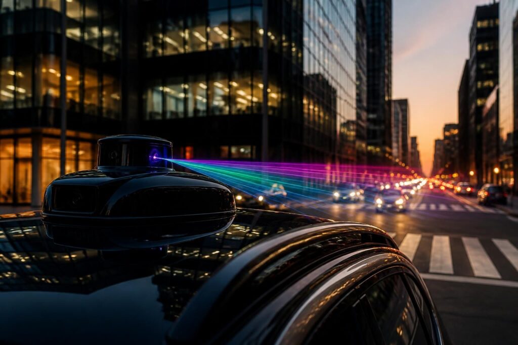
What Makes This LiDAR Different From Everything Before It
For years, LiDAR sensors have been a cornerstone of autonomous navigation. They shoot laser pulses and measure how long they take to bounce back, building precise three-dimensional maps of the surrounding environment. The catch? Those maps have always been colorless — dense clouds of points floating in grayscale, like a world seen through frosted glass.
That limitation is now being challenged by a new generation of sensor technology described as the world’s first native color LiDAR. Unlike previous systems that stitched color data from a separate camera onto a LiDAR point cloud, this approach captures color and depth simultaneously, from the same sensor, at the same moment. The result is a fundamentally different kind of spatial data.
How Native Color LiDAR Actually Works
Traditional LiDAR systems operate in the near-infrared spectrum, a range invisible to the human eye but well-suited to precise distance measurement. Color, however, lives in the visible spectrum — red, green, and blue wavelengths that cameras capture but standard LiDAR ignores entirely.
The new native color approach uses multi-wavelength laser pulses that span both the visible and near-infrared ranges. By firing and detecting light across these multiple channels simultaneously, the sensor can record not just the distance to a surface but also its reflectance across different color bands. This gives each point in the resulting cloud a genuine RGB value derived from actual laser returns, not from a camera image projected onto it afterward.
This distinction matters more than it might seem. When color comes from a camera, it is subject to lighting conditions, lens distortion, and the geometric challenge of aligning two physically separate sensors. Native color data, by contrast, is inherently registered to the depth information because it comes from the same source. There is no alignment problem to solve.
“Color and geometry captured together, natively, from a single sensor — that changes what machines can understand about the world around them.”
Why Color Matters for Autonomous Systems
You might wonder whether color is really that important for a robot or a self-driving car. After all, these systems already navigate complex environments using existing sensors. The answer is that color carries an enormous amount of semantic information that grayscale point clouds simply cannot convey.
Consider a few practical examples:
- A red stop sign versus a green road sign — same shape, very different meaning.
- A pedestrian wearing dark clothing against a dark background — much easier to detect when color contrast is available.
- Road markings such as yellow center lines or white lane edges — color distinguishes them instantly from surrounding pavement.
- Vegetation versus painted surfaces — both can appear similar in depth data but differ sharply in color.
- Traffic lights — the entire function of which depends on color recognition.
In each of these cases, adding reliable color information directly to the 3D point cloud means autonomous systems can make faster, more confident decisions without relying on a separate camera pipeline to fill in the gaps.
Implications for Robotics Beyond the Road
Self-driving cars tend to grab the headlines, but the impact of native color LiDAR extends well beyond automotive applications. Industrial robots working in warehouses need to identify objects by type, not just location. Agricultural robots must distinguish ripe fruit from unripe fruit, or detect disease in crops. Search-and-rescue drones could more reliably identify people or hazards in cluttered disaster zones.
In construction and infrastructure inspection, colored point clouds make it far easier for engineers to review digital twins of buildings or bridges, because the model looks like the real structure rather than an abstract geometry. Surveyors and geospatial professionals have long used aerial LiDAR combined with photogrammetry to add color to their scans — a native color sensor would dramatically simplify that workflow.
Even in consumer robotics, a home assistant robot that can see color natively in 3D would be far better equipped to find your red coffee mug on a cluttered kitchen counter than one relying on a depth sensor alone.
Technical Challenges Still to Overcome
Despite the excitement, it is worth being clear-eyed about where this technology stands. Firing lasers across multiple visible wavelengths simultaneously introduces engineering complexity. Visible light is scattered more by atmospheric particles than near-infrared, which can reduce effective range in adverse weather conditions like fog or rain — already a known weakness of standard LiDAR that this approach may amplify.
There are also questions of sensor cost and miniaturization. Current LiDAR units have dropped dramatically in price over the past decade, but multi-wavelength systems with the precision needed for native color are likely to be more expensive at first. Mass adoption will depend on whether manufacturers can bring those costs down to levels compatible with consumer vehicles or affordable robotics platforms.
Data volume is another consideration. Color point clouds contain significantly more information per scan than monochrome ones, which places greater demands on onboard processing hardware and storage systems.
A Meaningful Step Toward Machines That Truly See
The development of native color LiDAR represents a genuine conceptual shift in how machines perceive physical space. For decades, the field has worked around the limitation by fusing separate sensors — cameras for color, LiDAR for depth — and accepting the imperfections that come with that approach. A sensor that delivers both natively is not just an incremental improvement; it simplifies the entire perception stack.
As the technology matures and costs fall, it is reasonable to expect native color LiDAR to become a standard component in next-generation autonomous systems, from delivery robots navigating city sidewalks to inspection drones surveying power lines. The world has always been colorful. Now, for the first time, the machines mapping it can begin to see it that way too.